KATHMANDU: BMW is introducing a new 3D mapping system that combines navigation, the vehicle’s surroundings and driver-assistance information in a single display.
The new BMW Maps with Driver Assistance feature will begin rolling out to eligible vehicles equipped with BMW Operating System X from October 2026.
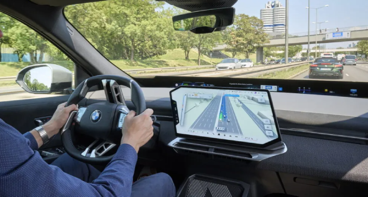
The system displays the vehicle’s position within the correct lane and road level. This is designed to make complex intersections, interchanges and multilane roads easier to understand.
Instead of showing navigation and driver-assistance information separately, the new interface combines them into one 3D view. It can show the planned route, the vehicle’s surroundings and the assistance functions currently supporting the driver.
BMW developed the system in-house, while Mapbox provides the mapping and navigation technology.
The feature also works with BMW’s Highway Assistant 2. The system can control acceleration, braking and steering on approved highways at speeds of up to 130 km/h.
With an active route, the system can assist the driver from an entrance ramp to the appropriate exit. It can also support lane changes after the driver confirms the maneuver through a glance.
BMW says the new 3D display does not increase the level of vehicle automation. The driver still needs to supervise the system and remain responsible for driving.
The October rollout will be available in selected markets, cities and roads. It will be offered on eligible BMW vehicles equipped with Highway Assistant or Highway & City Assistant.
BMW has not yet announced US-specific availability, pricing or a complete list of eligible models.
Germany is scheduled to receive navigation-guided semi-automated urban driving from 2027. Other markets could receive the technology later.
BMW’s new 3D Maps is different from LiDAR. It is a software-based system, not a physical sensor. LiDAR helps the car see its surroundings, while 3D Maps helps the driver understand them better.